Dry Forest Guanica
A forest like no other
 Located in the southwest corner of Puerto Rico overlooking the tranquil Guánica Bay, the Guánica State Forest spans 9,000 acres and ranks among the largest tropical dry coastal forests in the world. This is Puerto Rico’s most arid land, barely touched by rainfall throughout the year (in stark comparison to the lush El Yunque subtropical rainforest. What’s even more amazing is that these drastically different environments are less than two hours away from each other.)
The bosque seco, or dry forest, is what is known as a xerophytic forest. Home to hundreds of plant species (including numerous cacti, spiny bushes and short, squat trees), more bird species than the aforementioned El Yunque, and several reptilian and amphibian species, it’s a place of stark, dramatic beauty, a desiccated landscape that has an almost haunted beauty.
Because of its unique climate and native flora and fauna, the Guánica dry forest has been labeled a United Nations biosphere reserve.
It’s a day trip from San Juan (and a highly recommended attraction if you’re in the south of the island) that’s well worth it for a chance to explore a special place.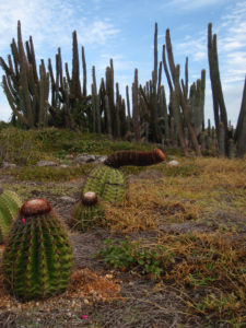
Visiting the forest:
Getting here: From San Juan, take Expressway 52 south to Ponce. From here, take Route 2 west to Route 116. From Route 116, take Route 334 to the forest. You’ll see a welcome sign at KM 6 on Route 334. Give yourself two hours from San Juan to the forest, less than a half hour from Ponce.
Planning your trip: The forest is open from 9am to 5pm. There’s no charge to visit. Begin your trek at the welcome center, where you’ll find a park ranger, trail maps and information, and restroom facilities. You’ll want to wear a hat, apply generous amounts of sunscreen, and bring lots of water. This is a dry, hot environment with trails that range from easy to challenging. Dress accordingly!
What to see and do: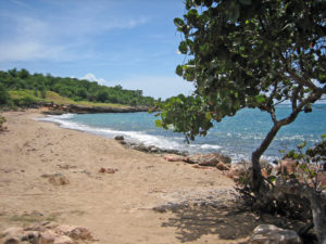
There are several trails here, but plan for a full day in the forest to get the most out of it. The most popular is also one of the longest: the four-mile trek to the ruins of historic Fort Caprón. This is a wide trail (almost a road) so it’s easy to navigate. Depending on when you visit (I was there in August), you might see the forest looking almost healthy and green, if you’re here during wet season–I use that term relatively–or you might see a more skeletal ambience, with trees and shrubs bare. Birdsong will accompany you, and the large cacti and lizards in the brush will be the only noises to permeate the otherwise deep silence of the forest. Along the way, you’ll catch panoramic views of the bay and an abandoned sugar mill.
A lookout tower is about all that’s left of the fort, with nature reclaiming most of what was once here. And while this bastion of Spanish military engineering never saw significant action, it’s worth noting that it did face the first U.S. soldiers who invaded Puerto Rico during the 1898 War with Spain. The woefully undermanned tower didn’t put up much of a fight, but my guide found shells from an American rifle nearby on one of his trips here. When you get here, you’ll come to a curving stairway that leads to the ramparts of the tower, where you’ll be treated to sweeping views and (hopefully) a nice breeze. You can also enter the tower, which has been covered with graffiti over the years.
If you don’t want to do (or don’t have time for) the full four-mile hike to the tower, here’s a tip. Stay on Route 334 past the entrance to the forest. Once you pass Jaboncillo Beach, you’ll see an old water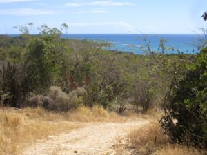 tower on your left. Pass this landmark and you’ll come to an unofficial entrance to the forest on your left with just enough room to park a car or two. There are no signs, so keep a close lookout for it. From here, a narrow trail (unmarked) will take you to the forest and take a few hours off your hike.
The fort trail is one of several that wind their way through the forest. The Ballena Trail is shorter and takes you down to Ballena Bay and to a side trail that leads to a centuries-old Guayacán tree. Other trails lead to natural caves and the coastline.
As seen in: http://gopuertorico.about.com/od/puertoricodestinations/p/Discover-The-Natural-Wonders-Of-The-Guanica-Dry-Forest.htm